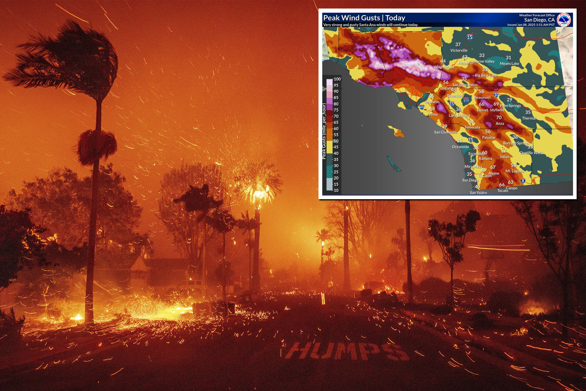
The ferocious wildfires turning areas of Los Angeles into raging infernos are being fueled by “hurricane force” Santa Ana winds that have already prompted the evacuation of tens of thousands of people and are rapidly destroying homes.
Santa Ana winds, which are common in Southern California during cooler months, are behind some of the Golden State’s most vicious fires.
They are notorious for turning small sparks into destructive, out-of-control blazes that can spread at great speeds.
The ferocious wildfires turning areas of Los Angeles area into raging infernos are being fueled by “hurricane force” Santa Ana winds, weather experts say. AP
As fire crews continue to battle the current wildfires across the Pacific Palisades and surrounding areas, here is everything you need to know about the Santa Ana winds currently wreaking havoc as gusts reach a staggering 100 mph:
What are Santa Ana winds?
Santa Anas are dry and warm northeasterly winds that blow from Southern California’s interior towards the coast.
The winds — often dubbed “Devil Winds” — are believed to be named after the Santa Ana Canyon in Orange County.
How do the Santa Ana winds form?
The winds are created by high pressure over the Great Basin — a desert region that spans several states, including California, Nevada, Oregon and Utah.
As the air squeezes through the mountain ranges and canyons that separate the desert from the coastline, it becomes drier and warmer.
Southern California was battered late Tuesday and early Wednesday by abnormally strong Santa Ana winds roaring down the inland mountain slopes. NWS
During a Santa Ana wind, humidity levels often plunge to single digit percentages — causing vegetation to significantly dry out and become extremely susceptible to fire.
Ferocious wind speeds can stoke any spark — for example, from a fallen power line — into a rapidly spreading blaze.
What direction do the Santa Ana winds blow?
Santa Ana winds move clockwise, in the opposite direction to the usual flow that moves moist air from the Pacific Ocean onshore.
So how are they impacting the Palisades fire?
Southern California was battered late Tuesday and early Wednesday by abnormally strong Santa Ana winds roaring down the inland mountain slopes — with gusts reaching up to 100 mph, weather experts said.
“We had a wind report come in a few minutes ago of 100 mph not far from Pasadena as the Santa Ana wind event has been ongoing,” Fox Meteorologist Christopher Tate told The Post first thing Wednesday.
Local fire officials have called the blustery conditions a “worst case scenario” for fighting the wildfires.
Stay up to date with the NYP’s coverage of the terrifying LA-area fires
“The biggest thing that you need for fire propagation is a source of oxygen,” Tate said. “And with the winds being able to transport so much of the smoke and the burned matter away from the fires, there’s a whole lot of oxygen that’s available to the fires and it makes it very easy for all of them to spread.”
Dry conditions have also exacerbated the spread of the fire and relative humidity has also been down below 20% across the Los Angeles metropolitan area.
When are the Santa Ana winds supposed to stop?
The wind is expected to relent slightly by Wednesday afternoon, with gusts forecast to drop to 30 to 60 mph.
Tate said the predicted wind drop will at least “light enough that firefighting aircraft can get airborne again and try and attack the fires from the air.”
With Post wires
Checkout latest world news below links :
World News || Latest News || U.S. News
The post What causes the Santa Ana winds — and how they fuel LA blazes like the Palisades Fire appeared first on WorldNewsEra.

