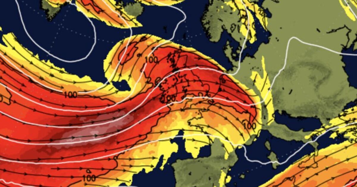
Weather maps show Storm Eowyn’s sheer power (Image: NetWeather)
Terrifying Storm Eowyn could be Britain’s “worst in years”, experts fear – as weather maps show the sheer power set to smash into the UK on Friday.
Pronounced ‘Ay-oh-win’, it’s the fifth winter storm of the season and named after a brave heroine in Tolkien’s Lord of The Rings trilogy, in the films played by Miranda Otto.
And with gales set to reach up to 90mph in northern Scotland, the Met Office has upgraded yellow wind warnings to a life-threatening ‘amber’ for swathes of the UK from 6am-9pm Friday – with a yellow wind warning in Scotland kicking in from midnight to 3pm Saturday.
Areas affected by the “danger to life” amber warning include North-West and North-East England, Yorkshire, Scotland, Midlands and Wales.
One Irish weather expert fears Eowyn could even be the worst to hit our shores in years – as Britons are urged to batten down the hatches and stay safe.
Alan O’Reilly from Carlow Weather wrote on X, formerly known as Twitter: “The overnight charts for #StormÉowyn are concerning as the high resolution models show damaging gusts across the country and this could be the worst storm we have seen in years.”
Don’t miss… Met Office issues amber warnings as 80mph Storm Eowyn looms – areas affected [LATEST]
The Met Office amber warning means a high risk of power cuts and mobile phone outage, as well as disruption to road, rail, air and ferry services, bridge closures and damage to buildings.
More worryingly, amber also means “injuries and danger to life could occur from flying debris, as well as large waves and beach material being thrown onto sea fronts, coastal roads and properties.”
And flagging possible 90mph-plus gales the Met Office adds: “This will bring a spell of very strong west to southwesterly winds, with peak gusts of 60-70 mph fairly widely inland, 70-80 mph in some areas, and 80-90 mph along more exposed coasts and hills (perhaps even higher in a few locations).”
Alarming weather maps by Netweather and www.WXCharts.com show the extent of the storm front set to crash into the UK’s western coastline on Friday.
Met Eireann – the Republic of Ireland’s forecasting agency – has also issued a nationwide Status Orange wind warning for between 2am and 5pm on Friday.
Amber alerts have been issued to a huge chunk of Britain (Image: MET OFFICE)
Calm before the storm – Jogger in Wednesday’s fog along the River Mersey in Wallasey (Image: AFP via Getty Images)
Don’t miss… ‘Magic’ exercise keeps hands warm in the winter – and takes just 30 seconds [LATEST]
Storm Eowyn will also bring with it rain and even snow (Image: WXCharts.com)
On Wednesday, Met Office forecaster Clare Nasir explained: “Winds will be relatively light as we head into the early hours of Thursday morning, in Northern Ireland you will see the winds strengthen as cloud thickens and rain moves in.
“This rain will turn heavy for a time as it pushes into western Scotland on Thursday morning rush hour, Wales as well as the west country seeing the heavy rain around mid-morning, then it moves eastwards.”
She added there will be “snow over the Highlands” of Scotland by midday Thursday and a strong breeze as temperatures struggle to reach 5-6C – the more showers will soak the UK by the afternoon as the “blustery” wind soars in power.
But it’s Friday when Storm Eowyn finally smashes into Britain with Met Office Amber and Yellow Warnings for wind kicking in through until Saturday – with winds exceeding 90mph.
Snow is also prodicted for parts of Scotland as Eowyn sweeps in to the UK wreaking havoc.
Weather maps show when Storm Eowyn will be unleashing her full force across UK (Image: WXCharts.com)
Storm maps show potential for very strong winds and uplifts (Image: WXCharts.com)
The mercury rises slightly on Friday – reaching around 11C in London, Manchester and Cardiff – but the powerful gusts mean it could feel far colder.
Meteorologist Clare Nasir added: “Wind warnings have been issued for most of the country and there will be heavy rain associated with it as well, preceded by some snow across central and northern Scotland.”
The looming stormfront is sparked by a powerful jet stream pushing low pressure across the Atlantic and towards the UK, following a recent cold spell over North America, the Met Office said.
And there is the potential for further weather warnings over the weekend and throughout next week, the Met Office added.
When Storm Eowyn will hit?
The storm is likely to hit the west coast of Ireland at around 8pm on Thursday evening bringing with it fierce gales.
WXCharts graphs show the winds of around 60mph will hit the south west of Britain at around midnight followed swiftly after by the full force of 80-90mph winds hitting both Cornwall and Wales.
By this time the strong gales are creeping across the middle of Britain covering the whole nation by 6am on Friday morning.
Throughout the day the storm will move northerly with the amber warnings taking full effect around 9am in the north of England and south of Scotland.
By early evening on Friday most parts of Britain will see relatively calm conditions with central and north Scotland the exceptions.
Checkout latest world news below links :
World News || Latest News || U.S. News
The post Storm Eowyn could be ‘worst in years’ as amber warning issued to swathes of UK appeared first on WorldNewsEra.

