
The UK will remain a patchwork of yellow weather warnings until Monday (Picture: Getty)
We’re about to see the back of Storm Eowyn – but the miserable UK weather like rainfall and severe winds isn’t going with it.
Eowyn (pronounced ‘Ay-oh-win’) pelted the UK yesterday with record-breaking 114mph winds – the equivalent of a Category 3 hurricane.
And that strong gale, recorded at Mace Head along the Irish coast at 5am, was only the beginning.
Gales of nearly 100mph lashed Northern Ireland, southern Scotland, and northern and western areas of England and Wales, knocking out power lines and leaving one million people without electricity.
The Met Office issued a raft of weather warnings – including a rare red alert – as the winds turned mundane objects into dangerous projectiles. In County Donegal, a man died after a tree fell on his car.
But the weather service revealed last night that Eowyn will ‘gradually clear’ today as it drifts into the Norwegian Sea.
What weather warnings are in place this weekend?
In its wake, four yellow weather warnings are in place today for wind, snow and ice.
An alert for ice, active until 10am, stretches across most of Wales, South West England and parts of the Midlands. Drivers have been warned of ‘hazardous travelling conditions’.
Snow and ice will also give motorists headaches elsewhere in the UK. A snow and ice warning covering all of Northern Ireland until 10am says snow showers and ice stretches will cause delays to public transport.
Classic wintry weather will strike two-thirds of Scotland – weather officials are telling Scots to get out their snow ploughs as up to 10cm of the white stuff is expected.
Four yellow alerts for ice, snow and wind are active today (Picture: Metro)
The Darnley Sycamore, which had stood tall for more than 400 years, was uprooted in Glasgow (Picture: Media Scotland)
To view this video please enable JavaScript, and consider upgrading to a web
browser that
supports HTML5
video
Wind, however, will cause further misery today in Scotland. Gusts between 70-80mph are possible around the hills and coasts of the Northern Isles.
The warning is in place until 3pm. Forecasters say the bitter winds will slowly ease in the south as the day goes by.
Until then, however, weather officials fear the wind may knock out power for even more Scots, disrupt travel
Another storm system is forecast to bring similar hazards for Britain tomorrow and Monday. Mainly rainfall, and a lot of it.
Winds of up to 70mph will lash the coast (Picture: Metro)
Flooding is expected amid the heavy rainfall (Picture: Metro)
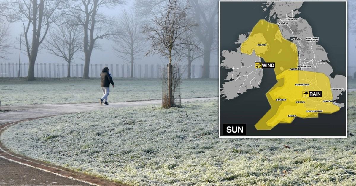
Up to 50mm of rainfall will soak London and some patches of the Midlands, North West, South West, South East and East England. The rain yellow warning is in effect from 8am tomorrow to 6am Monday.
‘Given recent heavy rain, this extra rainfall could lead to some local surface water and river flooding,’ weather officials stress.
A yellow wind warning will cover most of the western coastlines of the UK as well as all of Northern Ireland until 3pm Sunday. Winds of 70mph may whip up waves and spray along the coast.
Get in touch with our news team by emailing us at webnews@metro.co.uk.
For more stories like this, check our news page.
Arrow
MORE: Strictly live tour issues apology as fans complain cancellation took ‘too long’
Arrow
MORE: The vital service still hitting the road in the face of 114mph Storm Eowyn
Arrow
MORE: Full list of UK school closures after Storm Eowyn hits
Checkout latest world news below links :
World News || Latest News || U.S. News
The post Maps show where rain and snow warnings are across the UK following Storm Eowyn appeared first on WorldNewsEra.