
There was flooding along the River Severn in Worcester on Wednesday (Picture: Emma Trimble/SWNS)
For those of us fed up with the threat of snowfall looming overhead, good news – the white stuff is going to be replaced with the wet stuff.
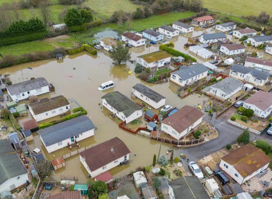
We’ve seen dozens of warnings for snow, ice, and rain across the UK in recent days, causing power cuts and flooding and even leading to comparisons with the Alps.
Wednesday was a bit more settled weather-wise, with two yellow warnings for ice and rain issued – but poor conditions will increase again today with 10 warnings in place.
The Met Office has put nine rain warnings and one ice warning in place at various times on Thursday, covering large swathes of the UK.
Met Office chief forecaster, Neil Armstrong, said: ‘After a relatively calm day on Wednesday, wet and windy weather will move in from the west on Wednesday night.
‘Low pressure will drive several days of unsettled conditions with heavy rainfall the main concern.
‘We have issued a number of severe weather warnings for rain across the UK, as much as 80mm of rain could fall in some areas of the west, particularly higher ground.
There was also flooding in Somerset earlier this week (Picture: Daniel Jae Webb/SWNS)
There are warnings covering large swathes of the UK (Picture: Metro Graphics)
‘Higher ground in eastern Scotland could even see up to 100mm of rain. Our warnings are likely to be updated so keep up to date with the Met Office forecast.
‘The rain will be falling on already very wet ground and where there is still lying snow in the northwest of England and parts of Scotland, snow melt will exacerbate the risk of flooding.
‘It is important to check for flood warnings in your area issued by your local environment agency.’
The full list of warnings and where they cover is as follows:
Yellow rain warning – 12am-7pm – south west England from Land’s End to Wareham
Yellow rain warning – 11am-10pm – south west England from Wareham to Worthing
Yellow rain warning – 12am-6pm – south wales from St David’s to Chepstow
Yellow rain warning – 12pm-8pm – central England from Worcester to Mansfield
Yellow rain warning – 10am-4pm – Northern Ireland from Ballycastle to Newry
Yellow rain warning – 7pm Wednesday-4am Thursday – covering most of central Northern Ireland
Yellow rain warning – 12am-7pm – Cumbria
Yellow rain warning – 12am-6pm – south west Scotland from Stranraer to Lockerbie
Yellow ice warning – 3pm Wednesday-10am Thursday – covering northern England, central Scotland, and the Orkney and Shetland Islands
Yellow rain warning – 6am-11.59pm – eastern Scotland from Aberdeen to Perth
A spokesman for the forecaster added: ‘Heavy rain is expected to arrive early on Thursday and then persist for much of the day.
‘Whilst some snow is expected to fall initially over higher ground, this should tend to turn to rain which will then steadily thaw lying snow.
More: Trending
’30-50 mm of rain is likely to fall widely with potential peaks over hills of 80-110 mm.
‘Rain will be accompanied by strong southeasterly winds.
‘Further heavy rain is possible in similar areas on Friday but this aspect is currently unclear.’
Get in touch with our news team by emailing us at webnews@metro.co.uk.
For more stories like this, check our news page.
Get your need-to-know
latest news, feel-good stories, analysis and more
This site is protected by reCAPTCHA and the Google Privacy Policy and Terms of Service apply.
var notifyQ = function () {
var i = 0,
l = awaitingReady.length;
for (i = 0; i
Checkout latest world news below links :
World News || Latest News || U.S. News
The post UK braces for a deluge as snow is replaced with heavy rain appeared first on WorldNewsEra.