
Many parts of the country will see another waterlogged day (Picture: PA)
More rivers are predicted to burst their banks today, causing flooding in areas from the north to the south of England.
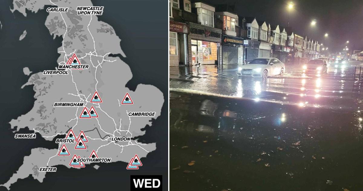
Twenty flood warnings are place where it is very likely to happen, while a further 90 alerts set out areas where flooding is possible.
It comes as the Met Office also issued a yellow weather warning for heavy rain in the North East of England lasting until 3pm.
Flood warnings were updated overnight for the River Anker in Warwickshire, and areas around the River Blackwater near Southampton.
It comes after a wet week, with another weather warning for thunderstorms in the south of England only lifted at 3am.
Showery rain was expected to push into eastern parts of England today, with sunny spells developing in the south.
Vehicles drive down water-logged country lanes in Dunsden, Oxfordshire, this morning (Picture: Geoffrey Swaine/Shutterstock)
A car on a flooded road in Grangetown, Sunderland, yesterday (Picture: Billy Malcolm William Smillie/PA)
(Picture: Metro.co.uk)
Eight of the alerts are in areas around Manchester (Picture: Gov.uk)
Other warnings were issued for Gog Brook in Warwick, Bunches Brook from Broadway to Childswickham in Worcestershire, and for low-lying properties near the River Brue and Glastonbury Millstream from Lovington to Highbridge in Somerset.
A warning was also issued for the B1040 Thorney to Whittlesey Road to the south of the River Nene near Peterborough.
More Trending
On Tuesday evening, an MP warned that parts of Northumberland were experiencing ‘severe flooding’ amid ‘extreme conditions’.
The 20 areas where flooding is expected
Alfriston on the Cuckmere River
B1040 Thorney to Whittlesey Road to the South of the River Nene
Bristol Avon (upper) from Chippenham to Melksham
Bristol Avon (upper) from Malmesbury to Chippenham
Bristol Frome from downstream of Nibley to Stapleton
Hellingly and Horsebridge on the Cuckmere and Bull Rivers
Landford to Wade Bridge on the River Blackwater
Middle Stour from Hammoon to Sturminster Marshall
River Alne at Chapel Lane and Church Lane in Aston Cantlow and Great Alne
River Anker at Mancetter, Witherley and Atherstone
River Irk at Chadderton Fold
River Irk at Cheetham Hill
River Irk at Crumpsall Hospital
River Irk at Kendall Road
River Irk at Little Green
River Irk at New Bridge
River Irk at Rhodes and Middleton
River Irk at Vale Park Industrial Estate
River Rother at Beighton
Rivers Stour and Iwerne at Stourpaine
A further 90 alerts are in place for possible flooding across the UK.
Blyth and Ashington MP Ian Lavery said his office had ‘taken numerous calls about the serious flooding’ in south-east Northumberland.
In a post on social media, Northumberland county councillor Scott Dickinson said: ‘A number of roads have been closed in the Blyth area and NCC teams are at the scene, along with crews from Northumberland Fire and Rescue Service, Northern Powergrid and Northumbria Water.’
National Highways said the M5 in Somerset was temporarily closed southbound on Tuesday afternoon due to flooding after heavy rainfall.
Get in touch with our news team by emailing us at webnews@metro.co.uk.
For more stories like this, check our news page.
MORE : Downpours to bring two inches of rain across London in matter of hours
Get your need-to-know
latest news, feel-good stories, analysis and more
This site is protected by reCAPTCHA and the Google Privacy Policy and Terms of Service apply.
var notifyQ = function () {
var i = 0,
l = awaitingReady.length;
for (i = 0; i
Checkout latest world news below links :
World News || Latest News || U.S. News
The post Map shows where 20 flood warnings are in place across UK appeared first on WorldNewsEra.