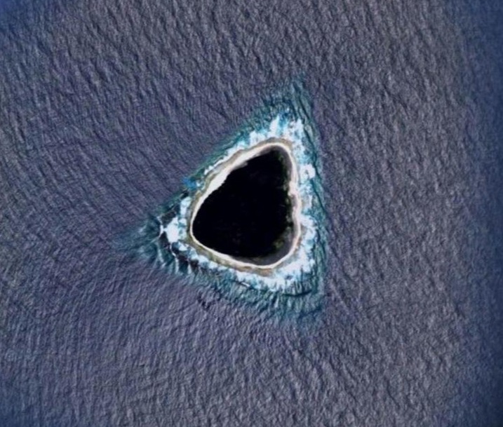
A DEEP SEA diving expert has revealed eerie secrets about a “hollow island” that’s been blacked out on Google Maps.
The hidden place is also said to be surrounded by deadly sea beasts and has never had anyone step foot on it.
The ‘hollow’ Vostock Island just off the Pacific Ocean has finally had its biggest secret revealed about why it looks so blackGoogle Earth
YouTubeOnly a handful of people, mainly divers have ever seen the island causing people to make up their own theories online[/caption]
For decades there have been theories over why there’s a strange, dark mass in the middle of the Pacific Ocean known as Vostock Island.
The aerial view from Google Maps blew up social media with wacky conspiracy’s and wild speculation as people desperately tried to solve the case of the mystery hollow island.
Some claimed it’s a “censored” destination that only the elite know about as others called it a top secret military base that’s meant to be kept private.
Others even pitched the idea that it could be the spot of a dangerous black hole.
The tiny island looks like it has a hollow, black centre, as only the sandy beach around it is visible.
The mysterious spot is also said to be very well protected with up to 15 sharks and tons of menacing barracudas prowling around.
Schools of fish also visit the lonely spot to enjoy its virtually untouched waters.
The confusing landmass is easy to miss as it sits alone and surrounded by deep blue waters.
There’s never been any sign of settlers and only the occasional diver has seen what the coral island has to offer.
This is believed to be because the island is so hard to actually get onto.
With no simple route or harbour in sight it’ll take a near-perfect action plan for explorers to even get onto the land.
But the true reason for the unknown spot on maps is much simpler.
The island covers just 1.3km in length and is shaped like a near perfect triangle but it’s the towering trees that have long been mistaken for something much more sinister.
Most of the place is made up of pure Pisonia trees that can grow up to 98ft and give off the dark green appearance that’s sparked conspiracy theories for decades.
These trees block out most of the sun and take up an incredible amount of space.
Elsewhere on the island a huge number of animals roam freely.
Seabirds, skunks, crabs and turtles make up a lot of the wildlife but its the unique Polynesian rat that’s the most populated species.
The coral island was first spotted by a Russian explorer who named it after his ship – The Vostock.
Since then several places have staked a claim to owing it including the US before it became a British Colony up until 1979.
It then became part of newly independent Kiribati who still own it to this day.
It’s not uncommon to find whole areas blacked out on Google Maps.
From military bases to mysterious islands, there’s no shortage of censored locations that the digital mapping service keeps hidden from users.
Recently a conspiracist claimed on TikTok that a “mysterious” group of islands off Dubai are “apocalyptic safe zones” for the rich and famous.
The 300-strong archipelago in the Persian Gulf looks like a world map and one suspicious user reckons people are planning their escape in case the world ends.
Elsewhere a tiny island in the Caribbean that’s home to a huge theme park and water attraction could be one of he worlds most fun secrets.
Perfect Day at CocoCay is a private island belonging to Royal Caribbean and is only known about to a select group of travellers.
AlamyThe mysterious island actually looks like a black, hollow hole because of the huge number of trees covering the spot[/caption]
Google EarthThe mysterious aerial view of the island from Google Maps that has sent the internet wild[/caption]
Sharks and barracudas protect the island and swim around it alongside thousands of other fish

